


Forts Pernante - Giaure - Marguerie

jlrayon
User
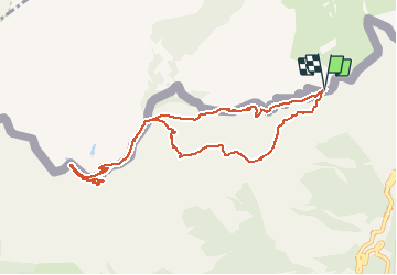

Length
13.1 km

Max alt
2274 m

Uphill gradient
654 m
Km-Effort
22 km

Min alt
1842 m

Downhill gradient
658 m
Boucle
Yes
Creation date :
2019-01-15 13:22:28.646
Updated on :
2019-01-15 13:22:28.646
4h29
Difficulty : Difficult

FREE GPS app for hiking
 SityTrail
IGN / Geographical institutes
SityTrail Plus
The world is yours!
About
Trail Walking of 13.1 km to be discovered at Piemont, Cuneo, Limone Piemonte. This trail is proposed by jlrayon.
Description
Du col de Tende géographique au Fort De Giaure par le Fort Pernante, retour par le Fort de la Marguerie. (projet)
Positioning
Country:
Italy
Region :
Piemont
Department/Province :
Cuneo
Municipality :
Limone Piemonte
Location:
Unknown
Start:(Dec)
Start:(UTM)
384626 ; 4889254 (32T) N.
Comments